By James Case
BOOK REVIEW: Waking the Giant: How a Changing Climate Triggers Earthquakes, Tsunamis, and Volcanos. By Bill McGuire, New York, Oxford University Press, 2012, xiv+303 pages.
Bill McGuire is a professor of geophysical and climate hazards at University College London. He was a member of the UK Natural Hazard Working Group, established in January 2005 following the Indian Ocean tsunami, and was appointed in 2010 to the UK Scientific Advisory Group for Emergencies to address the volcanic ash problem caused by the Eyjafjallajökull eruption in Iceland that spring.
As a volcanologist, McGuire is keenly aware of the ways in which volcanic activity affects the global climate. Indeed, after a major eruption, global temperatures typically decline by several degrees, due to absorption and the increased reflectivity of the resulting cloud cover, and sometimes require years to recover. In this, his fifth book, McGuire argues that the arrow of causality points both ways. Volcanic activity causes climate change, and climate change can trigger lithospheric (including volcanic) activity. Mathematical models purporting to explain the mechanisms involved are under development.
In 1977, McGuire first visited the Valle del Bove (Valley of the Oxen), a gigantic amphitheater carved out of the eastern flank of Mount Etna, in Sicily, to gather data for his doctoral thesis. Knowing that rainfall in the Mediterranean had increased significantly as ice age glaciers receded, he guessed that the eastern flank of Mount Etna had become saturated with water, causing (as in the Los Angeles area during an El Niño spring) a mudslide of epic proportions and––in all probability––a catastrophic tsunami. Confirmation of such a hypothesis might begin with a search for evidence of the “lost tsunami.”
Recently, a team of volcanologists employed a nonlinear PDE model of surface wave propagation to simulate such an event [2]. Assuming that about 8000 years ago a 25-cubic-kilometer landslide moving at roughly 360 km/hour entered the Ionian Sea in a matter of minutes, the team estimated the effects of the resulting waves on the soft sediments carpeting much of the Ionian seafloor, along with shoreline effects in the eastern Mediterranean. Although sea levels have risen about 10 meters in the last 8000 years, substantial quantities of evidence are still to be found.
Joseph Boussinesq derived the first relevant partial differential equation in 1872, in an effort to explain the experimental results obtained by John Scott Russell regarding solitary traveling waves (solitons) in canals. Because a number of similar equations have since been derived, students of the subject now refer to equations of “Boussinesq type.” It was realized around 1980 that anticipated increases in computing power would soon make it possible to analyze and predict, affordably and with considerable accuracy, many instances of nearshore hydrodynamic behavior, including wave propagation and shoaling, wave/current interaction, wave breaking, and the generation of nearshore circulation.
Derivation of an equation of Boussinesq type begins with expansion of the vertical and horizontal components of flow velocity (or potential) in Taylor series around a reference elevation, truncated after a few terms; the equations expressing the irrotational and incompressible nature of the flow are exploited to eliminate vertical partial derivatives in favor of horizontal ones. The result is a single equation involving a single unknown function of (one or two) horizontal space variables representing the surface elevation above the reference.
With additional mild assumptions, Boussinesq’s original equation can be reduced to:
- The Kortweg–de Vries (KdV) equation for wave propagation in one horizontal space dimension,
- The Kadomtsev–Petviashvilli equation for wave propagation in two horizontal space dimensions, and
- The nonlinear Schrödinger equation.
The main predictions of this “lost tsunami” model are supported by a wealth of submarine evidence, including core samples from Holocene turbidite deposits at the bottom of the Ionian Sea, and now-submerged (yet well-preserved) remains of the neolithic settlement known today as Atlit-Yan, located some hundred meters offshore from the current coast of Israel. The site shows evidence of hasty abandonment, including––beneath a protective coating of clay––a quantity of fish already gutted and sorted according to size, for anticipated consumption or trade. McGuire describes a number of other prehistoric undersea landslides, the largest being the so-called Storegga landslide and tsunami, which occurred off the coast of Norway near the end of the last ice age.
Needless to say, the effects of another such tsunami––were it to occur today––would be devastating. The most imposing current threat appears to come from the Cumbra Vieja volcano, on the island of La Palma, in the Canary Islands. The seaward flank of that still active volcano appears to be unstable, and a computer model of the tsunami that can be expected from a future collapse has been constructed [3]. The worst-case scenario predicts that a huge initial dome of water, about three-quarters of a kilometer high, would form within two minutes of failure. Within ten minutes, the shores of nearby islands would be struck by a series of immense waves; perhaps an hour later, waves several stories high would reach the northwestern coast of Africa. After 12 hours, the eastern Caribbean would be deluged, and waves as high as 8 meters would inundate the coast of Florida.
Earthquakes can also be triggered by climate change. As thick ice sheets form, the underlying lithosphere is depressed. The resulting stiffness causes the ground immediately surrounding the sheet to flex upward, forming a boundary ridge, or “forebulge,” as shown in Figure 1. As the ice melts, the depressed portion of the lithosphere rebounds, forcing the surrounding ridge to migrate outward––albeit at glacial speeds––away from the former margins of the ice sheet. As applied to North America, this effect could explain not only the otherwise mysterious earthquakes near New Madrid, Missouri, in December 1811––and continuing into February 1812––but also the large and damaging quake that struck Charleston, South Carolina, in 1886.
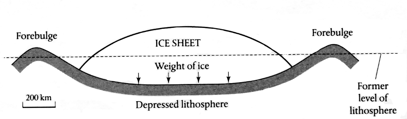
Figure 1. Bouncing back. As an ice sheet melts, the depressed underlying lithosphere rebounds, forcing the surrounding ridge––the “forebulge”––to migrate outward. The phenomenon could explain otherwise mysterious earthquakes in North America––including those near New Madrid, Missouri (1811), and Charleston, South Carolina (1886). Figure from Waking the Giant.
|
A recently developed finite element model [4] seeks to predict the arrival of such post-glacial pulses of seismic activity at various places in North America. Although it predicts the timing and magnitude of the prehistoric quakes known to have occurred in Quebec and Indiana, the model has difficulty with the New Madrid events––it gets the timing right but fails to predict the magnitude of the recorded shocks. Subsequent research by the U.S. Geological Survey suggests, however, that the New Madrid quakes may have been less powerful than previously believed, possibly falling within the range predicted by the model.
Discussing volcanic eruptions as yet another possible consequence of climate change, McGuire points out that twenty thousand years ago, Iceland was completely covered by an ice sheet more than 800 meters thick. As the ice melted, the depressed lithosphere rebounded by as much as 450 meters, dramatically decreasing the pressure on the underlying strata and thereby unleashing a 30-fold increase in magma production. The resulting burst of volcanic activity lasted more than a millennium. Much the same reaction might be expected from the Grimsvötn volcano, currently resting beneath the Vatnajökull ice cap, should the latter continue to melt at anything like the present rate.
Most of the world’s volcanos are located near the Pacific rim, close to the water’s edge. Rising sea levels, as they press down on the base of a volcano, seem to be able at times to force magma out of them, much as toothpaste can be forced out of a tube. McGuire cites evidence of such forcing on the Pavlof volcano, in the Aleutian peninsula. Rising sea levels there each autumn apparently irritate Pavlof. During the period from 1973 to 1998, 13 of the volcano’s 16 eruptions occurred between September and December, when sea levels are at their highest.
Rising sea levels threaten the stability of faults separating adjoining tectonic plates, as, for example, the San Andreas fault separates the Pacific and the North American plates. A recent study [1] from the Scripps Institution of Oceanography concluded that the bending of the lithosphere resulting from a large rise in sea level could “unclamp” the San Andreas fault, possibly unleashing “the big one” so often evoked by Californians. Similar conclusions apply to the Anatolian fault, which transects northern Turkey and was the site of the Izmit earthquake that killed 17,000 people in 1999.
It is too soon to estimate the extent of the damage to be expected from human-produced global warming. But McGuire has begun to catalog the more obvious dangers, and suggests that mathematical modeling––together with the fieldwork performed by earth scientists––seems to be capable of assessing the associated risks.
References
[1] K. Luttrell and D. Sandwell, Ocean loading effects on stress at near shore plate boundary fault systems, J. Geophys. Res., 115 (2010), B08411; doi:10.1029/2009JB006541.
[2] M.T. Pareschi, E. Boschi, and M. Favalli, Lost tsunami, Geophys. Res. Lett., 33:22 (2006), L22608; doi:10.1029/2006GL027790.
[3] S.N. Ward and S.J. Day, Cumbre Vieja volcano––potential collapse and tsunami at La Palma, Canary Islands, Geophys. Res. Lett., 28 (2001), 397-400.
[4] P. Wu, and P. Johnson, Can deglaciation trigger earthquakes in North America?, Geophys. Res. Lett., 27 (2000), 1323-1326.
James Case writes from Baltimore, Maryland.