Network Science for Environmental Problem Solving
By Jacopo A. Baggio and Jesse S. Sayles
The United Nations recently earmarked $18 billion USD to restore 150 million hectors of degraded habitat by 2020 [1]. Landscape scale restoration is clearly a global priority, but achieving this goal will be no small feat. The mathematics of network science, however, can help.
Landscape restoration requires both knowledge of the biophysical and the socio-political environment. Recovery of degraded environments cannot be done in isolation; rather, recovery must be coordinated across different socio-political boundaries. Actions in one location affect those elsewhere. For example, efforts to improve water quality by one municipality can quickly be negated by neighboring municipalities that do not take similar actions. Upstream degradation will affect downstream environments, and migratory species need healthy habitats along the entire river corridor. River systems do not respect juridical or political boundaries, nor do air quality, invasive species and fires, floods, pests, and species migration.
This “misalignment” between environmental processes and governance boundaries is known as spatial misalignment, or spatial social-environmental scale mismatch, and is frequently cited as a fundamental sustainability challenge. Overcoming mismatches requires political will, and human and financial capital; mathematics, and network science more specifically, can play a key role in analyzing and diagnosing socio-environmental scale mismatches.
Our work, recently published in the Proceedings of the National Academy of Sciences [2], showcases new methods to analyze scale mismatches and social-ecological networks by looking at salmon restoration in Puget Sound, Washington. The quality of riverine and nearshore habitat is paramount for salmon populations to thrive, and is the focus of much restoration activity in Puget Sound. While our study area is a cohesive bio-physical unit, restoration activities are planned and implemented by over 100 organizations working in different locations, at local and regional levels, and spanning public, private, and nonprofit sectors. To study possible scale mismatches, we approach the system as a social-ecological network.
Following the language of network science, we represented both organizations and natural resource areas as nodes. The presence of inter-organization collaborations, the quality of collaborations, geographic location, and bio-physical linkages (i.e., rivers and coastlines) between natural resource areas were represented as edges. We then used network analysis to identify potential scale mismatches (i.e., where restoration organizations have few collaborations but work in connected habitat areas), the strength of networks meant to overcome scale mismatches (structurally in terms of vulnerability to targeted node removal, and functionally in terms of collaboration productivity), and network shapes that relate to productive collaborations.
The framework is based on a social-ecological network supra-adjacency matrix (see Figure 1) depicting which social nodes are connected (social-social [SS] edges), what ecological nodes they work in (social-ecological [SE] edge), and what ecological nodes are linked through ecological processes (ecological-ecological [EE] edges). The analysis iterates through the network and assigns a social-ecological membership (MBI) value to social nodes based on the ecological area(s) they work in (SE edges) and whether those areas are connected (EE edges). The membership index (MBI) allows us to analyze why some organizations have a local focus (they only work in one ecological area) while others have a regional focus (they work in multiple ecological areas).
Figure 1. Graphic representation of the data transformation and social-ecological network analysis. A represents how regional and local organization work on specific parts of the watershed. Considering who works with whom and where and how the watershed is connected leads to B: the construction of a social-ecological network/matrix. C showcases the process used to derive specific network metrics used first for the analysis and then to portray the maps shown in D.
We considered the simplest instance of potential scale mismatch, collaborations among organizations working in two connected ecological areas. The framework can be expanded, however, to include \(N\) ecological areas, which we discuss in our paper’s supplementary information [2].
While many factors can influence governance success, especially when dealing with high uncertainty and unknowable factors, mathematical tools—in this case, networks—can help us shed some light on the structure and dynamics of the coupling between the socio-political and the environment system. The correct use of networks can help us diagnose and overcome scale mismatches problems.
The results of this work can be used to guide management of natural resources (see Figure 2). While we cannot necessary predict future outcomes, it is possible to diagnose potential future problems and current areas of concern. Diagnostic approaches are a first step towards increasing success in natural resource management. Mathematical tools can help policy and decision-makers better allocate resources. For example, the correct use of networks can facilitate the identification of potential vulnerabilities in social-ecological systems [3], the evolution of collaborations [4] and their nature [5], and current and future potentially-problematic areas to manage [2].
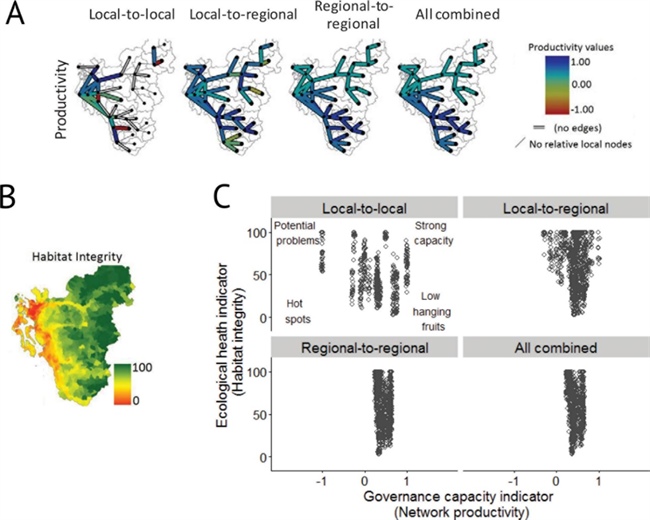
Figure 2. Example of prioritization of areas by overlaying the social-ecological network metrics. Panel A shows the productivity of collaborations among organization working in connected ecological areas (scored as a ratio where 1 = all collaborations are productive, -1 = all are unproductive, and 0 = a 50/50 split). Tiles show the interactions of actors working at different spatial scales. Panel B shows the habitat integrity index [6], and panel C shows the integration of the two and classifies areas accordingly. Each data point in C is a small landscape unit used by Washington State for analysis of biophysical conditions affecting salmon habitat. Integrating the ecological health indicator with a governance capacity indicator helps illustrate the range of problems and opportunities facing landscape managers. There may be hotspots that have both degraded environment and governance challenges. Recovering salmon in these areas will require restoring ecological habitat and building the social infrastructure to do so. In other areas with strong governance, providing resources to address ecological degradation may be sufficient (i.e., low-hanging fruits). Healthy habitat in areas with governance challenges could turn into potential problems; if habitat conditions worsen, these areas may not have the governance capacity for restoration.
Landscape restoration, together with other pressing environmental issues of our time—such as air and water quality, water availability, fisheries management, invasive species, and wild fires—require coordination and cooperation at different socio-political levels, from local organizations and political parties to nation states and supranational organizations. There is a need for a wider and more nuanced use of mathematical instruments in the social and social-environmental sciences, coupled with theoretical development, case study analysis, and experimental studies. Only through true interdisciplinary and multi-methodological approaches will we be able to shed light on and hopefully solve the complex problems of our time.
References
[1] Menz, M.H.M, Dixon, K.W, & Hobbs, R.J. (2013). Hurdles and Opportunities for Landscape-Scale Restoration. Science, 339, 526-527.
[2] Sayles, J.S., & Baggio, J.A. (2017). Social-ecological network analysis of scale mismatches in estuary watershed restoration. Proc. Natl. Acad. Sci., 114, E1776–E1785.
[3] Baggio, J.A., BurnSilver, S.B., Arenas, A., Magdanz, J.S., Kofinas, G.P., & De Domenico, M. (2016). Multiplex social ecological network analysis reveals how social changes affect community robustness more than resource depletion. Proc. Natl. Acad. Sci., 113, 13708-13713.
[4] Schoon, M., York, A., Sullivan, A., & Baggio, J. (2017). The emergence of an environmental governance network: the case of the Arizona borderlands. Reg. Environ. Chang., 17, 677-689.
[5] Sayles, J.S., & Baggio, J.A. (2017). Who collaborates and why: Assessment and diagnostic of governance network integration for salmon restoration in Puget Sound, USA. J. Environ. Manage., 186, 64-78.
[6] Wilhere, G.F., Quinn, T., Gombert, D., Jacobson, J., & Weiss, A. (2013). The Puget Sound watershed characterization project volume 2: a coarse-scale assessment of the relative value of small drainage areas and marine shorelines for the conservation of fish and wildlife habitats in Puget Sound Basin. Olympia, WA: Washington Department of Fish and Wildlife.
Jesse S. Sayles is a human-environment and sustainability scientist that focuses on governance networks of watershed and coastal systems. He is currently working as a postdoctoral fellow at McGill University with the Climate Change Adaptation Research Group. Jacopo A. Baggio is an assistant professor of human-environment system modelling in the Department of Environment and Society at Utah State University. His work focuses on identifying the drivers underlying the resilience of social-ecological systems.